General Information
Nahiya (Subdistrict)
Bilbilê
Also Known As
Ali Al-Atrash, Alî Kerê, Eli Kera, Elîkera, علي الأطرش, عليكار, علي كارو
Tribes
Qeregêç, Êla Biyan, Şikik
Families, Clans, etc.
Cibo, Ebnan, Eltîkê, Hesenê Nûrî, Kalê Hisûvî, Mala Birahîmê Gende, Mala Mihemedê Hûrîkê, Malbatê Elî, Malbatê Hisênê Kêlê, Malê Hemeş, Malê Silef, Malê Zine, Malê Çapo, Merna, Mola Qutû

Photos
Basic Information about Eli Kera
Source: Ax û Welat
Etymology: Named after its founder, Elî, who was hard of hearing (guh giran), leading to the name Elî Kera (Ali of the Deaf/Deaf Ali)
Springs: Kaniya Gund, Kaniya Dehar, Cinorî, Kaniya Qewaq
Hills: Girê Çûçik
Shrines: Ziyareta Şemsê, Şêx Hemze
Ruins: Xerabê Mola Qutû
Other Landmarks: Gailê Qutû
Summaries
I. Summary from TirejAfrin Site (English) of Eli Kera
Source: https://www.tirejafrin.com/site/kura%20afrin%20%20%20bilbile%20-%20%20eli%20kera.htm
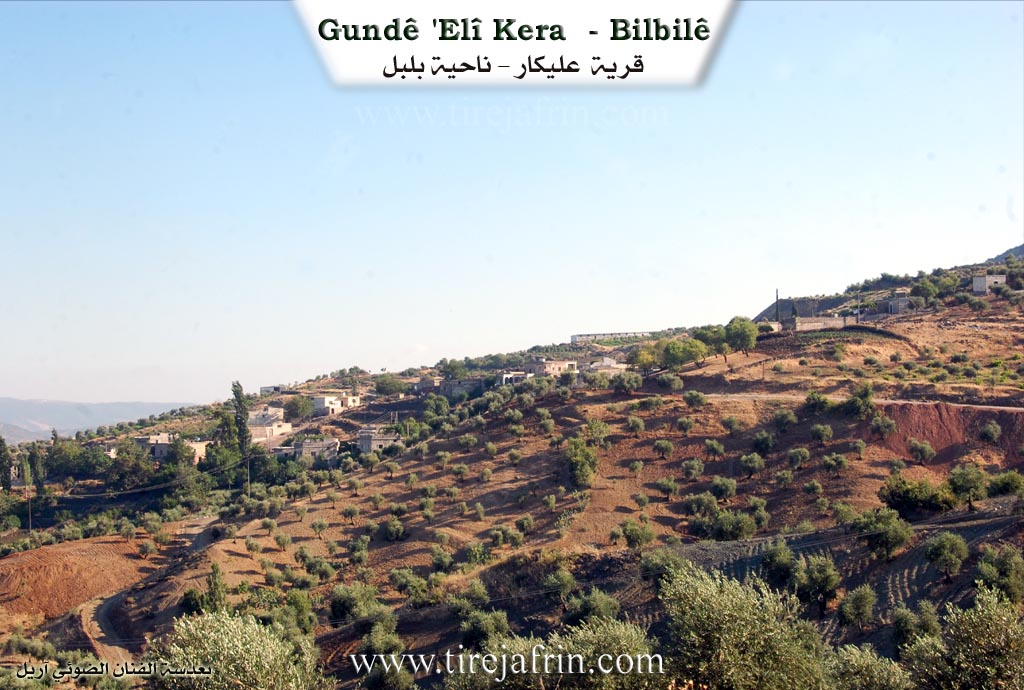
Elîkera, Elîkar, Elî Etreş / 699 people 130 hectares 5km 990m /
The name means "Ali the Deaf" (Elî Kerr), and the Arabized name is a translation of the popular name.
It is a small village located above the eastern slope of Mount Gir ik, and springs are abundant around it.
According to the book Efrîn... Her River and Her Green Hills: Elîkar is a village in the Kurd Mountain, affiliated with the Bilbil subdistrict, Efrîn region, Aleppo governorate. It is a small village situated on a rocky flat on the lower northern slope of the small Mount Damrik, which consists of limestone rocks covered in parts by green and basaltic rocks. It is located 5km northwest of Bilbil. Springs abound around it, and a watercourse descends from it toward the northeast where the agricultural lands have fertile volcanic soil.
It is bordered to the north by mountainous highlands planted with forest trees and the village of Bêk Obasî; to the south, at a distance of 500m, by the village of Hêyamli; to the west by a high mountain range planted with forest trees and the village of Kewanda; and to the east by a slope, a deep torrential valley, and the village of Zêre.
The number of its houses is about 35 houses, and its age is approximately 350 years. Its old houses are made of stone and mud with flat wooden roofs, while the modern ones are concrete in its north and south. An electricity network and a primary school are available in the village.
Most of its inhabitants work in the cultivation of olives and grains through rain fed farming on 130 hectares, and walnuts, almonds, and pomegranates through irrigation from the springs, in addition to raising sheep and goats. Others work in marble quarries near the village. The village drinks from spring water and cisterns that collect rainwater. Currently, the residents have equipped the spring with pipes to prevent water waste and use it for drinking only. An asphalt road connects it to the town of Bilbil, passing through its center to several neighboring villages.
Village Mukhtar: Nûrî Mihemed Elî
Sources of Information:
- Book: جبل الكرد (عفرين) دراسة جغرافية Çiyayê Kurmênc (Efrîn): A Geographical Study by د. محمد عبدو علي Dr. Mihemed Ebdo Elî.
- Book: عفرين .... نهرها وروابيها الخضراء Efrîn... Her River and Her Green Hills by عبدالرحمن محمد Ebdulrehman Mihemed from the village of Qetme.
- Studies of Navenda Tirej Soft / Ebdulrehman Hacî Osman.
- Some residents of the villages.
Preparation and Execution: Manager of the Tirej Efrîn website: Ebdulrehman Hacî Osman 20/12/2013
II. Summary of Eli Kera from Ax û Welat
Source: https://www.youtube.com/watch?v=iRShgMNe41g
The village of Elî Kera, located in the Bilbil district of the Afrin region, sits high on a mountainside near the border between Syria and Turkey. The village is known as the home of the Êla Biyan tribe. Its name is derived from its founder, Elî, a man who migrated from North Kurdistan (modern-day Turkey). Because Elî was hard of hearing, he was known as "Elîyê Ker," which evolved into the village name Elî Kera (or Elîkero).
The settlement history of Elî Kera is defined by migration and the consolidation of neighboring groups. Elî originally chose the location for its elevation and defensive advantages ("xwedêomparêz bû"). Shortly after his arrival, another figure named Hisênê Kêlê, also from the north, arrived with his family. Rather than conflicting, Elî offered Hisênê Kêlê land and water, establishing a bond of brotherhood that persists between their descendants. The village population grew as other groups joined, including the Mola Qutû family, who originally inhabited nearby ruins known as Xerabê Mola Qutû in the Gailê Qutû valley. Other families, such as Malê Zine, Malê Çapo, and Malê Hemeş, arrived later, along with migrants from the specific neighboring villages of Qerebaba, Kûra, and Xelîlaka.
The drawing of the political border significantly impacted the village's social geography. Historically, the residents maintained close ties with the city of Kilîs. The border separated the villagers from their ancestral lands and burial grounds. A major shrine and cemetery, Ziyareta Şemsê, was located on the line, separating the graves of the "Turkish side" from the "Syrian side." Consequently, the villagers established a new sacred site within their own territory, the shrine of Şêx Hemze. This shrine acts as a center for religious life and healing, where locals pray for recovery from illness and offer sacrifices during religious holidays like Qurban and on Fridays.
Social life in Elî Kera traditionally revolved entirely around communal sharing. Elders recall that during festivals, the entire village would gather under a large tree in the village center. Notable families, such as Malê Silef (specifically Kalê Hisûvî), Mala Birahîmê Gende, and Mala Mihemedê Hûrîkê, would take turns hosting these feasts.
Water is a central element of the village's identity. The main water source, Kaniya Gund, was historically an open spring near the central tree. In the past, figures like Hecî Tangî and Mamil led efforts to excavate the source from the cliffs (zinar) and channel it into the village using stone troughs. Today, the village remains an agricultural hub producing olives and sheep, but it also sees modern industry; a resident named Ziyad returned from Heleb (specifically the Şêx Meqsûd neighborhood) during the Syrian crisis to establish a workshop manufacturing truck parts from local earth and materials.
II. Summary of Eli Kera from Multi Channel
The documentary explores the village of Alî Kero located in the Bilbilê district of the Efrînê region. According to the village Mukhtar Nûriyê Elî Hesen, the settlement was founded six to seven hundred years ago by a man named Alî who originally migrated from Çiyayê Gewr. Because the founder was hard of hearing, people referred to him as deaf Alî, which translates to Alî Kero, giving the village its enduring name. The Mukhtar notes that there is also a sister village with the exact same name located across the border in Tirkiyê which stems from the same original lineage.
The village consists of around eighty to ninety households today. The descendants of the founder Alî still form the main core of the village population and are divided into three primary family branches, which include the Hesenê Nûrî and Ebnan families. Other notable residents interviewed include the elder Remezanê Îsmaîlê Cibo and Ebdilhekîmê Numan Merna. During his interview, Remezanê Îsmaîlê Cibo recites an old epic song that mentions the historical Şikik and Qeregêç tribes. The community is closely connected to surrounding settlements, as evidenced by a woman originally from the nearby village of Xelîl Ako who shares her experiences living in Alî Kero for over forty years.
A central historical and cultural feature of Alî Kero is the ancient plane tree Dara Çinarê which is estimated to be over four hundred years old. In the past, this massive tree served as the primary gathering place for the community. Residents would hold two day wedding celebrations, prepare bulgur wheat, and host visiting guests under its broad shade. Today many villagers treat Dara Çinarê as a sacred site, referring to it as a ziyaret, and approach it with deep reverence and caution. Another significant sacred landmark is the large hill known as Girê Zaîr which is situated near the neighboring villages of Ze'rê and Bîkê. This site is renowned as a holy place even as far away as the city of Helebê.
Historically the residents of Alî Kero engaged in diverse agriculture by planting crops like lentils, chickpeas, and barley. Today their farming is heavily focused on olive groves, vineyards, and small household gardens where they cultivate vegetables like peppers for their spicy local cuisine. Basic education for young children takes place in the village itself while older students must travel to schools in Qestelê Xidro or Bilbilê. Recently the village has been facing a severe water crisis. The historical village spring Kaniya Alî Kero which used to supply abundant water has completely dried up after new wells were dug in the surrounding lands. Villagers are now forced to manually carry water in buckets from lower elevations which has severely impacted their daily lives, their livestock, and their ability to maintain their gardens.
Transcriptions and Subtitles
| Source | Video | Subtitles | Transcript |
|---|---|---|---|
| Ax û Welat 1 | Watch Video | Download SRT | View Transcript |
| Multi Channel 1 | Watch Video | Download SRT | View Transcript |
Possible Village Name Meaning of Eli Kera
Means "lame Ali" (or deaf Ali); the Arabized name is a translation from the folk designation.
Source: TirejAfrin Site